| Sr No. | Title | Detail |
|---|---|---|
| 1 | Aerodrome Reference Code | 2-B |
| 2 | Aerodrome Reference Point | Elevation: 701ft (AMSL)
Latitude: 29°10’42.25″N Longitude: 075°45’17.04″E |
| 3 | Runway 12-30 | 1220 m X 45 m |
| 4 | Taxiway | 99 m X 18 m |
| 5 | Old Hangers (2 Nos.) | 21m X 29m and 22m X 26m |
| 6 | New Hanger (3 Nos.) | 37 m X 50 m |
| 7 | Apron in front of Old Hangar & TB | 60 m X 90 m |
| 8 | Apron in front of New Hangars | 345 m X 90 m |
| 9 | Terminal Building (for 50 PAX) | 450 Sq m approx. |
Other Buildings like admin block, flight complex with ATC tower, police post, hostel, dormitory, fire station etc., are in use at existing Hisar Airport.
| Sr No. | Title | Remark |
|---|---|---|
| 1 | Aerodrome Reference Code | 4-E |
| 2 | Aerodrome Reference Point
(Proposed) |
Elevation: 704 ft (AMSL)
Latitude: 29°11′ 25.16″N Longitude: 075°43′ 45″E |
| 3 | Runway 12-30 | 3000 m X 45 m |
| 4 | Blast Pad | 60 m X 60 m |
| 5 | RESA | 240 m X 120 m |
| 6 | Parallel Taxi Track | 3000 m X23 m |
| 7 | Taxiway btw Rwy & PTT (04) | 146 m X 23 m |
| 8 | Taxiway btw PTT & Apron | 1011 m X 23 |
| 9 | New Apron | 426.5 m X 125.5 m |
| 10 | GSE (02 Nos.) | 80 m X 62.5 m |
| 11 | Isolation Bay & Taxiway (23 M) | 117 m X 95 m |
| 12 | Standard Security Boundary Wall | 14732 m |
| 13 | Security Watch Towers | 29 Nos. |
| 14 | Exit Gates | 05 No s |
| 14 | Installation of AGL | Compatible for Cat-II operations |
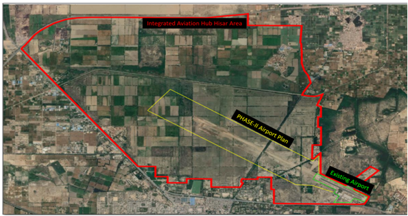
Phase-II Project Site location:
The development works under Phase–II of IAH project is planned over an area of approx. 4200 acres of land which includes the existing airport land and the additional adjoining Govt. of Haryana land of approx. 4000 acres.The airport development site under Phase-II of IAH project is highlighted in yellow


